Hikepack: Clever Hiking Maps 2.3
Free Version
Publisher Description
Plan ahead, stay on track, explore. Satellite & topo maps, trails, elevations, route planning and navigation. OFFLINE, with just one tap.
ONLY IN HIKEPACK, ALL OFFLINE:
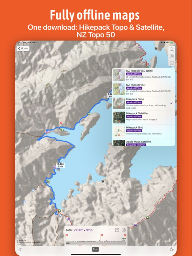
• One download: Trails, peaks and attractions with topo and satellite imagery covering the ENTIRE map.*
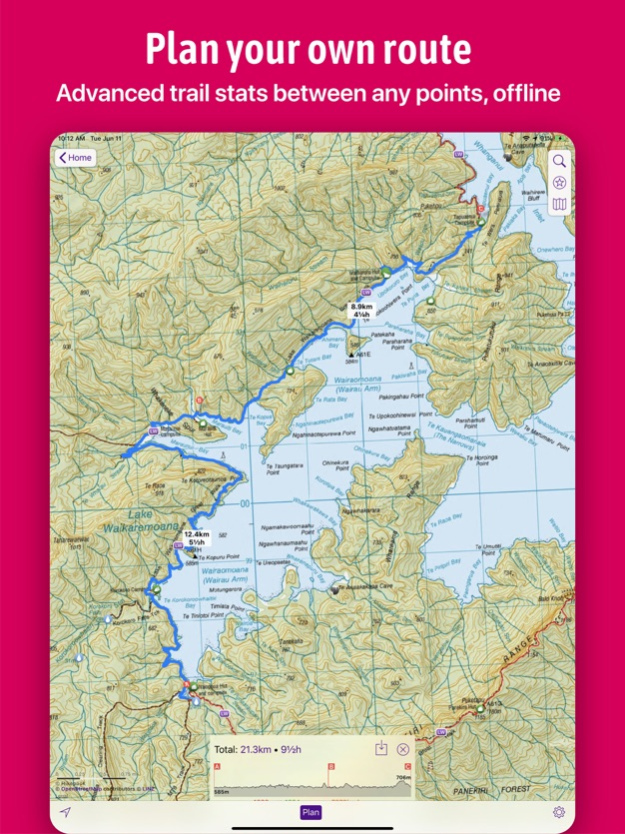
• Planning along trails: Plan your own custom route along existing map trails by simply dropping pins on the map.
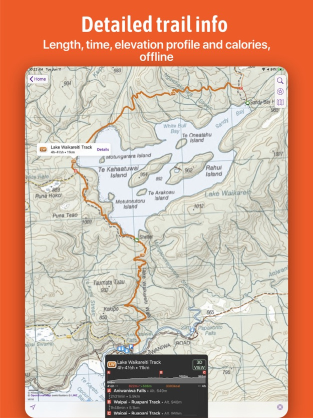
• GPS Navigation: Time, distance, elevation profiles, total ascent, descent, and calories.
• Get Me There: While hiking, see the remaining time, distance and route to any map symbol or to any dropped pin.
PLAN YOUR TRIP
• See elevation profiles and other advanced trail stats (length, hiking time, ascent/descent, calories)
• Plan your own route, and see the same advanced trail stats also for it
• See the altitude of any point on any route
WHILE YOU HIKE
• See the remaining time and distance to any location, and find the shortest route to it
• See your location on the map
FEATURES IN DETAIL
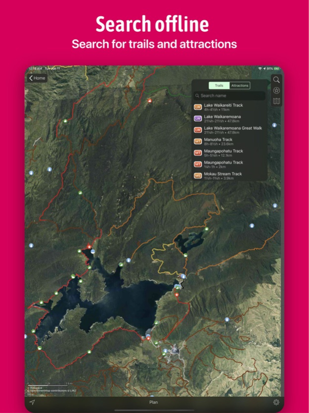
• Hikepack intelligently extracts all hiking, biking and cross-country ski trails and points of interest from OpenStreetMap data, and packs them into one download. So you have a curated map focused on outdoor activities.
• The topographic and satellite map layers are created by Hikepack, from open data.* They cover the ENTIRE map, which means you're never lost. This is made possible by our proprietary compression algorithms, that allow for a small download and a smooth experience.
• All the routing is done on your device. So if you're in the middle of a hike and without cellular signal, you still see the remaining hiking time and distance to your destination.
• You can save the routes you planned in one map, and then compare their elevation profiles at a glance.
• You can change the hiking speed used for computing hiking time estimates.
• You can filter what points of interest you see on the map.
• You can measure distances in a straight line, between any points, but they will not take the terrain into account.
••• You can download as many maps as you wish for free offline use, but some features require a Pro Pass subscription.
We're just getting started, and we'd love to hear from you! Suggest new maps or features by sending an e-mail to hello@hikepack.earth, or using the Feedback form in the app.
We regularly publish new maps in Hikepack. Currently, we cover all US national parks: Grand Canyon, Great Smoky, Yosemite, Zion, Rocky Mountain, Yellowstone, Olympic, Acadia, Grand Teton, Glacier, Joshua Tree, Cuyahoga Valley, Bryce Canyon, Hawai'i Volcanoes, Arches, Hot Springs, Shenandoah, Mount Rainier, Death Valley, Haleakala, Sequoia, Capitol Reef, Badlands, Everglades, Saguaro East, Saguaro West, Canyonlands, Crater Lake, Theodore Roosevelt, Petrified Forest, Wind Cave, Kings Canyon, Mammoth Cave, Mesa Verde, Redwood, Lassen Volcanic, Glacier Bay, Carlsbad Caverns, Virgin Islands, Great Sand Dunes, Big Bend, Channel Islands, Kenai Fjords, Voyageurs, Black Canyon of the Gunnison, Pinnacles, Guadalupe Mountains, Great Basin, Congaree, Katmai, North Cascades.
We also cover 40 US national forests, and many other parks, all UK national parks, 35 maps in Finland covering the main hiking areas, from the northern-most parts of Lapland, to popular parks near Helsinki, and 37 maps in Romania covering most of the Carpathian mountains.
----------
* Satellite imagery available only for selected maps in the US and Finland only. The topo layer available for all maps.
** The maps are created by Hikepack from open data. See the details page of each map for the copyright holders.
Jun 11, 2019
Version 2.3
This update fixes several bugs and issues, including those with submitting feedback or requests for new maps.
About Hikepack: Clever Hiking Maps
Hikepack: Clever Hiking Maps is a free app for iOS published in the Recreation list of apps, part of Home & Hobby.
The company that develops Hikepack: Clever Hiking Maps is Alexandru Ioan Tomescu. The latest version released by its developer is 2.3.
To install Hikepack: Clever Hiking Maps on your iOS device, just click the green Continue To App button above to start the installation process. The app is listed on our website since 2019-06-11 and was downloaded 1 times. We have already checked if the download link is safe, however for your own protection we recommend that you scan the downloaded app with your antivirus. Your antivirus may detect the Hikepack: Clever Hiking Maps as malware if the download link is broken.
How to install Hikepack: Clever Hiking Maps on your iOS device:
- Click on the Continue To App button on our website. This will redirect you to the App Store.
- Once the Hikepack: Clever Hiking Maps is shown in the iTunes listing of your iOS device, you can start its download and installation. Tap on the GET button to the right of the app to start downloading it.
- If you are not logged-in the iOS appstore app, you'll be prompted for your your Apple ID and/or password.
- After Hikepack: Clever Hiking Maps is downloaded, you'll see an INSTALL button to the right. Tap on it to start the actual installation of the iOS app.
- Once installation is finished you can tap on the OPEN button to start it. Its icon will also be added to your device home screen.
